
Tags
CAMS Global Wildfires Review 2024: A Harsh Year for the Americas, Climate Change, Copernicus Atmosphere Monitoring Service (CAMS), Eaton Fire/Los Angeles County January 2025, Global Wildfire Information System (GWIS), International Wildland-Urban Interface Code (IWUIC), National Centers for Environmental Information (NCEI), National Oceanic and Atmospheric Administration (NOAA), National Weather Service (NWS), Palisades Fire/Los Angeles County January 2025, Santa Ana Winds/Southern California, Warming Planet, Western Fire Chiefs Association (WFCA), Wildfire Risk, Wildfires, Wildland-Urban Interface Zones, World Weather Attribution (WWA)
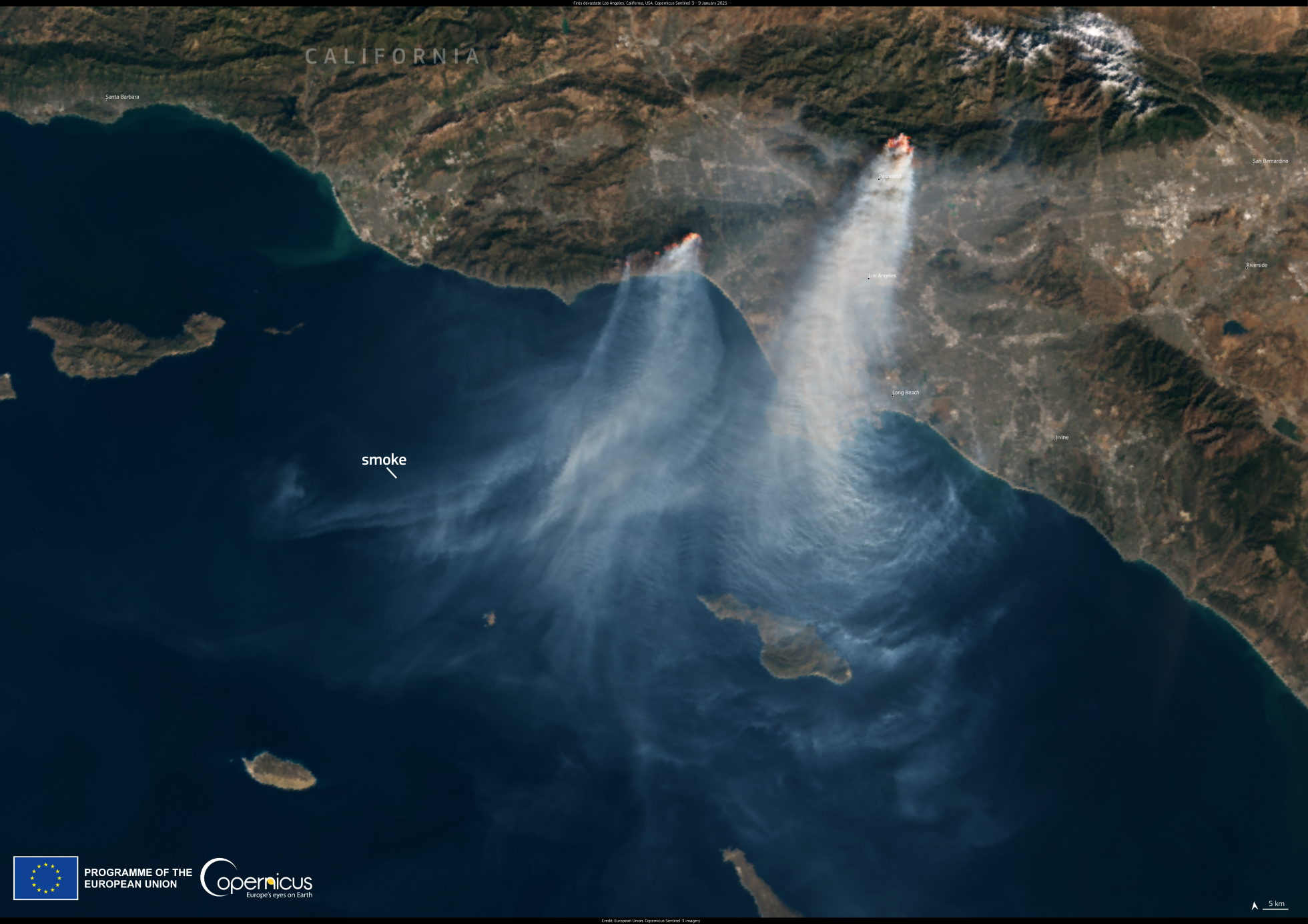
Source : Copernicus European Union
On Tuesday, January 7th, in Los Angeles, our year began with wildfire like no other. I first learned about the Palisades Fire, which ignited at 10:30 a.m. in the affluent Pacific Palisades neighborhood, when I tuned into our local TV news broadcast at noon that day. At that moment, I was not alarmed. Like earthquakes, wildfires all year round have become a part of living in California. Besides, this was not the first wildfire in this area. On December 9th, 2024, the Franklin Fire had set more than 4,000 acres (16 square kilometers) ablaze in neighboring Malibu over nine days.
When I tuned in again that evening around eight o’clock, I was shocked to learn that a second wildfire, named the Eaton Fire, had ignited further inland in Altadena, a working-class community just north of Pasadena, where the New Year’s Day Tournament of Roses Parade had celebrated “Best Day Ever!” as its theme for 2025. Who knew then, that the best day ever would end in tragedy seven days later for thousands of Altadena residents?
Even more alarming, the Palisades Fire, driven by exceptionally fierce Santa Ana winds blowing offshore from over the San Gabriel Mountains, was spreading like the fiery breath of an angry dragon. On following the local live newsfeed, I learned that an Evacuation Order went out for an area in the neighboring city of Santa Monica on the southeastern edge of the fire. My heart fluttered. The Palisades Fire was advancing closer to our home. How could this be happening?
At the same time, the northwestern edge of the fire expanded, leading to an Evacuation Warning for Calabasas, a city in the San Fernando Valley. My firstborn who works from home for a firm in Calabasas saw no need for concern…yet.
This was not a normal firestorm. That Tuesday night, I gathered documents, medication, and other important items. For the first time since moving to California, I slept in street clothes on the couch in the living room. My winter coat and boots were within reach near the exit. I was ready to evacuate, if needed.
After a restless night, as winds battered the Camellia trees, I woke early to a smoke-laden sky that blotted out the rising sun. Trees gyrated in the wind. With toxic particulates contaminating the air, we were alerted to stay indoors and wear N95 masks when going outdoors.
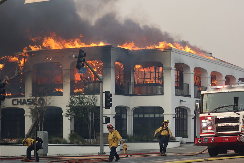
Photo Credit: Cal Fire Photo Album
I remained on alert during that week as firefighters battled to contain the flames. On Thursday, January 9th at 3:57 p.m., an Evacuation Warning sent out by the Los Angeles Emergency Alert System jolted me. Another emergency alert at 4:19 p.m., advising to disregard the Evacuation Warning intended for the Kennedy Fire only, did nothing to reduce my anxiety. Once again, Calabasas was under threat from another fire.
Over the years, we’ve experienced fierce Santa Ana winds that have knocked over my tall plants and even uprooted my croton bush. Since permanently securing these at-risk plants, I was happy to see them still standing. These winds, which usually occur from October through March, would be different, warned the National Weather Service (NWS). They predicted winds of over 60 mph (96.6 kph), with isolated gusts up to 100 mph (160.9 kph).
Based on the juxtaposition of the low and high weather systems, Los Angeles and Ventura Counties were especially at risk due to a “life-threatening and destructive windstorm.” On Monday, January 6th, California Governor Gavin Newson announced that the state was deploying resources—fire engines, hand crews, aircraft, and other additional support—to protect us here in Southern California.
The Santa Ana winds were very dry due to low humidity. Due to drought conditions in our region since April-May 2024, the soil and vegetation were also very dry. The atmospheric river system, that brought heavy rain to our region last winter, didn’t come our way this winter. One spark was enough to ignite the conflagration. The dry hurricane-force winds tossed smoldering embers as far as five miles (8 kms) away, rapidly spreading the fire.
The force of the Santa Ana winds and dense smoke made it dangerous to attack the flames from the air. Without air support, firefighters on the ground had to rely solely on water in the fire hydrants. The city’s water infrastructure, designed for routine isolated fires, was not equipped for the extreme demands of a large-scale wildfire. Blackout conditions, as a safety precaution, aggravated the situation.
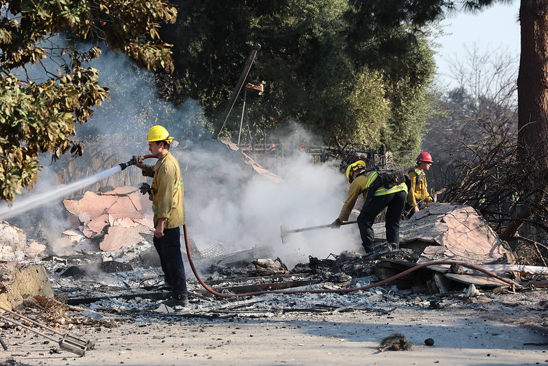
Photo Credit: Cal Fire Photo Album
Meteorologist Eric Holthaus said on Tuesday, January 7th, that Southern California is “facing a rare and dangerous juxtaposition of extreme winds and midwinter drought” that he described as “a worrying example of the state’s expanding wildfire threat as climate change worsens.
For readers interested in learning more about the unusual factors that combined to lead to this unprecedented event, I recommend that you read a preliminary analysis, “Climate Change A Factor In Unprecedented LA Fires,” published on January 13, 2025, by University of California – Los Angeles (UCLA) Geography Department.
Researchers at World Weather Attribution (WWA) from Belgium, Denmark, France, Sweden, the Netherlands, the United Kingdom, and the United States, also came to the same conclusion. In their research review, “Climate change increased the likelihood of wildfire disaster in highly exposed Los Angeles area,” published on January 28, 2025, they concluded: “Given all these lines of evidence we have high confidence that human-induced climate change, primarily driven by the burning of fossil fuels, increased the likelihood of the devastating LA fires.”
A 2021 study supported by the National Oceanic and Atmospheric Administration (NOAA) concluded that climate change has been the main driver of the increase in fire weather in the western United States. Climate change creates warmer, drier conditions, leading to longer and more active fire seasons. Check out the National Centers for Environmental Information (NCEI) for U.S. Wildfires for the years 2000 to 2024, showing total number of yearly fires and acres burned.
Based on data released by the California Department of Forestry and Fire Protection (Cal Fire), during the five-year period from 2020 to 2024, there have been a total of 38,931 wildfires (an average of 7,786 per year), burning a total of 8.6 million acres (an average of 1.7 million per year). The following charts are also available:
- Top 20 Largest California Wildfires
- Top 20 Most Destructive California Wildfires
- Top 20 Deadliest California Wildfires
The Western Fire Chiefs Association (WFCA) notes that historical trends show that wildfires are also getting worse worldwide. During the 1990s, approximately 78,600 wildfires burned an average of 3.3 million acres per year. Since 2000, a yearly average of 70,025 wildfires have burned a yearly average of 7 million acres, more than double the average burned in the 1990s. The shift in conditions is attributed to drier fire fuel influenced by climate change, as our planet continues to warm every year.
The top largest wildfires worldwide, burning over a million acres since 2000, based on data provided by Earth.org, include:
- 2003 Siberian Taiga Fires (Russia) – 55 million acres
- 2019/2020 Australian Bushfires – 42 million acres
- 2014 Northwest Territories Fires (Canada) – 8.5 million acres
- 2004 Alaska Fire Season (USA) – 6.6 million acres
- 2010 Bolivia Forest Fires (South America) – 3.7 million acres
- 2011 Richardson Backcountry Fire (Canada) – 1.7 million acres
- 2024 Texas Wildfires (USA) – 1.1 million acres
The Global Wildfire Information System (GWIS) also provides historical overviews of wildfire regimes by country and sub-country for the period 2002-2019.
For climate change deniers, it’s foolish to blame the devastation of these unprecedented wildfires in Los Angeles County on poor forest and water management. Instead, they should be regarded as yet another wake-up call from Mother Nature to the growing danger we humans face as our planet continues to overheat.
We cannot continue to build our homes and communities deeper into high fire-risk areas and expect firefighters to rapidly extinguish the flames. Rebuilding in these wildland-urban interface zones, like Pacific Palisades and Altadena, without hardening one’s home and community against wildfire, would be defying the gods. This is not cheap. Perhaps, that’s why California is not listed among the 24 American states that have adopted the International Wildland-Urban Interface Code (IWUIC) that provides guidance for safeguarding homes and communities from wildfire.
Though our city is not located in a wildland-urban interface zone, I know now that we are not 100 percent safe from wildfire risk. Not anymore on a warming planet. The scariest part of witnessing this natural disaster, that transformed two urban communities into what now look like war zones, is the way in which we can lose everything we’ve spent our lives working to attain in one instant. Worse still is losing one’s community—churches, commercial areas, health clinics, schools, and recreation centers—where one had raised a family, created memories, and built friendships.
I leave you with the following NASA satellite image of the Altadena community on January 11, 2025.
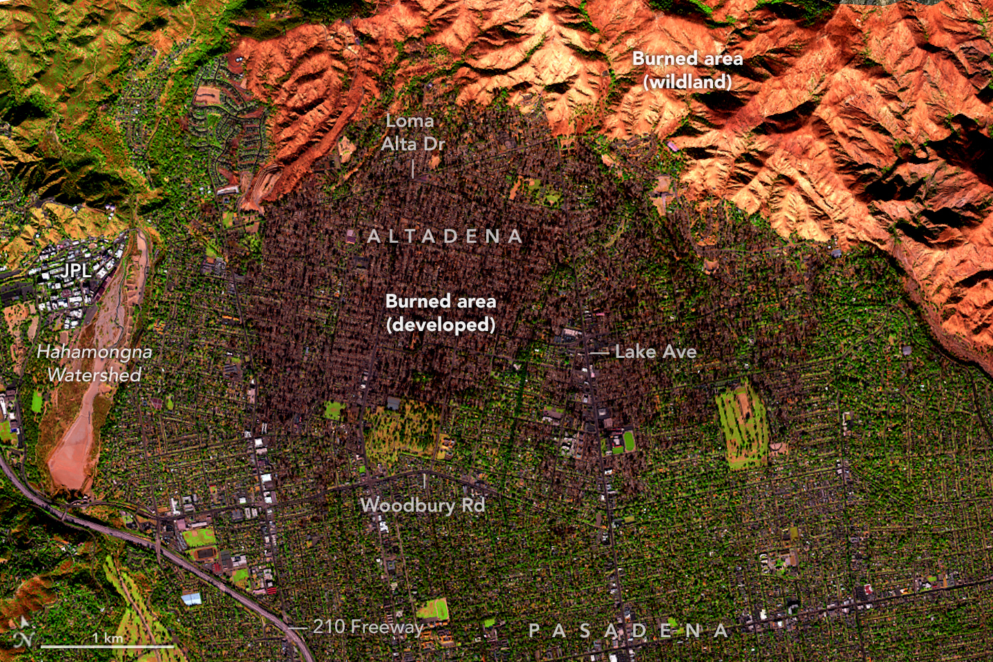
Photo Credit: NASA Earth Observatory
With a climate change-denier master at the helm, may the gods help us all.

I’m glad you are safe Rosalienne. The fires have been devastating to all affected and concerning for onlookers all over the world.
LikeLiked by 1 person
Thanks for dropping by, Kate. I still recall the horror of watching Australia’s 2019/2020 bush fires.
LikeLiked by 1 person
Terrible times Rosaliene but our country is always in natures tumultuous grasp. We have floods up north, it’s the wet season. It has always been the same here – just more people and more urban density so the affect is greater. My father once pointed out flood marks on ancient trees on our sheep station out west, he said “there have been greater floods then we have seen yet” riverbeds that once flowed differently. Nature will shake us off like fleas when she is ready, her power is incredible.
LikeLiked by 1 person
Kate, your father is so right about Nature’s incredible power.
LikeLiked by 1 person
I am so sorry to read this, Rosaliene. I had not realised it was so close to you. Your closing sentence is even more alarming
LikeLiked by 3 people
Thanks very much, Derrick. It took a while to focus on sharing this experience.
LikeLiked by 1 person
I’ll bet
LikeLiked by 1 person
It was in news for many weeks here Rosa, but overpowerd by Trumps inauguration celebrations. I am happy you are safe, but things natural have become more destructive now than in many generations before. We need to be agile and think far ahead.
LikeLiked by 2 people
Thanks very much, Narayan. I’ve printed the “Disaster Ready Guide” released by our Governor’s Office of Emergency Services for guidance.
LikeLike
So sad, Rosaliene. You have described this well. “We have met the enemy and they is us,” as Walt Kelly, the cartoonist, reminded us long ago.
LikeLiked by 1 person
Thanks very much, Dr. Stein. The best I can do is to be prepared emotionally and spiritually for whatever comes.
LikeLiked by 1 person
A terrifying experience, climate change is getting worse, and it seems nothing is being done about it.
LikeLiked by 1 person
Diana, thanks for dropping by. Powerful actors who don’t want change make it difficult for us to take action.
LikeLiked by 2 people
😣
LikeLiked by 1 person
A powerful, comprehensive, heartbreaking, you-are-there piece, Rosaliene. So sorry you were among the many who went through this. And, yes, those who say the devastating wildfires had nothing to do with climate change are disgusting liars.
LikeLiked by 2 people
Thanks very much, Dave. It took several attempts to focus to share this front-seat view of a climate disaster. There are hundreds of working-class families who will not be able to recover from their losses.
LikeLiked by 1 person
😦
LikeLiked by 1 person
Thanks for this first hand account of what it was like to live in the shadow of these fires. Appreciate it and glad to hear you made it through unscathed.
LikeLiked by 2 people
Thanks very much, Ken.
LikeLike
Rosaliene, I am glad you are safe, though probably traumatized. I’m sure it was a frightening time for you. I’m glad you put together this important analysis. Take care.
LikeLiked by 1 person
Kim, it was, indeed a frightening time. It took over two weeks for me to regain balance and focus on sharing this traumatic experience. Those who have lost everything are probably in a state of limbo as they move forward to rebuild their lives.
LikeLike
So sad to see this playing out while the Mocker in Chief is in charge. Climate Change Deniers are missing the entire point. Whether you think the climate change is caused or aggravated by humans is of little consequence. It is happening and will continue to increase as weather gets more unpredictable. We must take steps to mitigate while we still can, better forecasting, less combustible building materials and more conservation practices. Having folks in charge who know what is required is a lot better than having politicians release huge quantities of water from dams, serving little or no purpose at the time. Our wildfire in Jasper National Park and Jasper town is still a political football with folks trying to affix blame rather than fixing the problem. Hope your weather settles down to allow for recovery Rosaliene. Allan
LikeLiked by 1 person
Allan, thanks for sharing your own experience with wildfires in your state in Alberta, Canada. Based on data available online, the 2024 Jasper Wildfire burned 80,860 acres and topped the list of Canada’s 10 most important climate disasters in 2024. While our leaders play “political football” with these climate change disasters, the lives of thousands of people worldwide are at risk.
LikeLiked by 1 person
A sobering, up-close accounting of what it’s like to experience climate disaster firsthand. My heart aches for those directly impacted and those of you in the area living with that horrific possibility hanging over you, sleeping in street clothes near your boots and the door. It’s especially heartbreaking knowing it doesn’t have to be this way. So glad you and yours remained safe, Rosaliene.
LikeLiked by 2 people
Thanks very much, Tracy. It’s difficult to enter the mindset of those who know the human toll of their products, fossil fuels in this case, but do nothing to change course.
LikeLike
No matter how many wake-up calls occur, many people, unfortunately, will not respond in sensible ways.
LikeLiked by 2 people
Tragically true, Neil.
LikeLiked by 1 person
The only good news in this is that you are safe. What a terrifying experience to have gone through. With your current climate change denying president, things will only get worse. He’s determined to ruin all of North America and then I think on to the rest of the world. Maggie
LikeLiked by 1 person
Thanks very much, Maggie. Given his latest trade war with Canada and Mexico, it does look that way. The most recent move to close all USAID offices worldwide will definitely create turbulence.
LikeLiked by 1 person
Glad you stayed safe. These fires are awful! How frightening! The firefighters clearly had their hands full trying to deal with this.
LikeLiked by 2 people
Ada, thanks to our tireless firefighters, we are safe. They came from across our state, country, and from overseas, including Canada and Mexico. Some of our local firefighters also lost their homes in the fire. May firefighters everywhere be blessed ❤
LikeLiked by 1 person
What a nightmare! I hope you continue to stay safe.
LikeLiked by 1 person
Thanks very much, Ginger.
LikeLiked by 1 person
This is a chilling account of a horrendous, human-caused disaster, Rosaliene. Meanwhile, I learned yesterday that the climate change deniers in charge are wiping the very words from official websites, as if that act will convince the planet to stop heating up.
I am glad you and yours continue to be safe, and I hope that the newly declared trade sanctions won’t reduce Canada’s ability to send water bombers to aid in the protection of our friends and neighbours.
LikeLiked by 1 person
Steve, I give thanks for the Canadian firefighting team that came to our rescue. A team from Mexico also joined the firefighting taskforce.
Wiping certain words, like climate change, from official government websites is not new. He did the same during his first presidency. This time, he has gone much further in undoing all the former administration’s programs initiated and underway in transitioning to sustainable energy.
LikeLiked by 2 people
Ah, yes, I do recall that happening in v1.0, too. Outrageous.
LikeLiked by 1 person
These fires are so, so scary. I’m sorry you had/have to go through that, Rosaliene. When a bunch sprang up down here several years ago, I don’t remember ever having been so scared in my life. I’m glad your home is safe.
LikeLiked by 1 person
Thanks very much, Ilsa. I also remember the large wildfire that moved through San Diego several years ago. At the time, I was concerned for my brother and his family who were living in the city. Stay safe.
LikeLiked by 1 person
It’s somewhat ironic that it happened in a city where most of the elite probably own a house and so near Hollywood where it seems like the intention is to distract us from reality. Thanks for giving us a feeling of what it was like to be in there because as I think you said in an earlier post, it, in some form or another, will come knocking on all of our doors.
LikeLiked by 1 person
Mara, it’s indeed ironic. The Pacific Palisades and adjacent beach-side Malibu (both razed by the Palisades Fire) are upscale neighborhoods with multi-million-dollar homes owned by lots of people in the movie industry. I don’t think they saw it coming.
LikeLiked by 1 person
These are worrying times, for all humanity! I pray that you dear Rosaliene stay vigilant and safe 🙏🙏🙏
LikeLiked by 1 person
Ashley, your prayers are much appreciated. Only the gods know who will be hit next.
LikeLiked by 1 person
You have provided a lot of good, reliable information backed up by research and proper attributions, so thank you for that. My heart goes out to everyone impacted by these fires. The sad part is that it most likely is going to get worse in the coming years.
LikeLiked by 1 person
Peg, thanks for dropping by. In our post-truth world, I’m doing my small part in sharing reliable information about our climate crisis.
LikeLiked by 1 person
That must have been frightening to see it come so close to yourselves and to loved ones! Blessings to you all.
LikeLiked by 1 person
Thanks very much, Dawn. It was a scary two weeks while firefighters with air support battled to contain the fires. Thanks God, both the Palisades and Eaton Fires are now 100 percent contained.
LikeLiked by 1 person
❤ Thank God.
LikeLiked by 1 person
You must have been terrified, Rosaliene. I’m sorry for all of you in California who live in burned areas or ones with the potential to burn in the near future. Yes, it does remind me that all can be lost in minutes.
Even if someone doesn’t believe in climate change, why wouldn’t they want to care for the planet, respect, and nurture it? Thank you for telling us how these fires affected you, my friend.
LikeLiked by 1 person
Thanks for sharing your thoughts, Mary. It was, indeed, a terrifying time. With the fires now 100 percent contained, former residents can now begin the cleaning up process.
LikeLiked by 1 person
Oh my gosh, be safe, Rose. And so agree that we should stop rebuilding in fire/flood/coastal/storm-prone areas!
LikeLiked by 1 person
Thanks, Pam. I’m doing my best to stay attentive and safe. The former residents of the burned out areas are already planning to rebuild. Those with money will no doubt fire-proof their new homes. Former working-class homeowners will face an uphill battle to even rebuild. Their fight going forward will be to keep real estate developers out of their community.
LikeLiked by 1 person
Gosh I hope they are successful, Rose. These issues are all intertwined and if you keep allowing the rich to manipulate resources then only the rich will have access to resources and we will end up with a caste system and no one will care about the bottom rungs anymore. It’s heartbreaking ❤️🩹 and I’m sure these things keep you up at night as they do me.
LikeLiked by 1 person
Pam, those left behind after a natural disaster don’t make the news. It is, indeed, heartbreaking.
LikeLike
Nothing that matters seems to make the news anymore, Rose. It’s all about the big money grab that is going on across the country and for some reason, the masses seem to be A-OK with it.
LikeLiked by 1 person
Loud sigh…
LikeLike
My dear Rosaliene, I am so relieved to hear you are safe. This devastation is so heart-breaking. 😥 This part of your message is spot-on:
“For climate change deniers, it’s foolish to blame the devastation of these unprecedented wildfires in Los Angeles County on poor forest and water management. Instead, they should be regarded as yet another wake-up call from Mother Nature to the growing danger we humans face as our planet continues to overheat.”
Stay safe my friend. 😘🙏🏼🤗
LikeLiked by 1 person
Thanks very much, Kym ❤
LikeLiked by 1 person
You’re so very welcome Rosaliene. Please, please, please stay safe. Mother Nature can be so unpredictable sistah! 😊🙏🏼💖
LikeLiked by 1 person
Don’t I know it, Kym! We’re safe now from wildfires, but, as you know, there are other dangers moving at much faster speeds along digital highways.
LikeLiked by 1 person
Honey Rosaliene, as they say, “If it ain’t one thing, it’s another!” UGH! Remain vigilant sis! 🥰🙌🏼🤗
LikeLiked by 1 person
I’m glad that you’re safe but the news of the fires was devastating. Nature keeps warning us and we aren’t listening.
LikeLiked by 1 person
Thanks very much, Andrea. So true 😦
LikeLiked by 1 person
I’m very thankful you’re safe. Thank you for sharing this personal reality of what it’s been like – very frightening for so many. I hope you stay safe.
LikeLiked by 1 person
Thanks very much, JoAnna. We’re safe as the fires have all been contained. Phase One of clearing the burnt areas of toxic materials is now underway. We’ve been getting light rain, which is good.
LikeLiked by 1 person
I’m very glad the rain is helping.
LikeLiked by 1 person
Thanks for reporting on this, Rosaliene.
It actually gave me a much better overview of everything that went down than most news coverage.
Take care,
J
LikeLiked by 1 person
You’re welcome, Jim. So glad that my post offers a better overview.
LikeLiked by 1 person
Thank you for sharing this poignant post, Rosaliene.
Hailing from Australia, I know only too well about devasting bush fires and also floods. The frequency of both has escalated and cyclones have become more violent.
Global governments are happy to spend trillions on defense but minimal on fixing what is becoming a spiralling disaster. I despair for future generations as today, we’re not experiencing the brunt of this tragedy.
LikeLike
Nilla, thanks for visiting and sharing your own experience with wildfires in Australia. I believe that our governments worldwide are being hamstrung by the fossil fuel industry.
LikeLiked by 1 person
So glad that you and your family are safe and that these fires are contained. I appreciate the satellite imagery with your explanation that shows the geography of the fires well.
LikeLiked by 1 person
Thanks very much, Rebecca. The clean-up in the burnt areas is now in Phase Two. The rebuilding process will take years.
LikeLiked by 1 person